

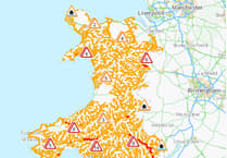
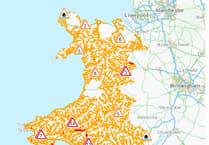
FORECASTERS have issued a yellow warning for strong winds later this week, following a mild Easter weekend.
The yellow warning warns of gusts of u to 60mph along the Irish Sea coastal areas, which will bring with them the possibility of large waves.
The yellow warning, issued by the Met Office for between 3pm on Tuesday and 6am on Wednesday covers all of Wales, but particular mention is given to west coast areas.
The Met Office says: "A developing area of low pressure running north through the Irish Sea is likely to bring a spell of strong winds, accompanied by some heavy rain, to parts of central and western England, Wales, southwest Scotland and the east of Northern Ireland.


"Gusts of 45-50 mph are possible inland and perhaps in excess of 60 mph for a time around some Irish Sea coastal areas."
Power cuts and travel delays are possible and it's likely, forecasters say, that some coastal routes, sea fronts and coastal communities will be affected by spray and/or large waves.
High pressure, which has been responsible for the dry and fine weekend weather for most, will move away to the east, to be replaced by a westerly Atlantic regime, with periods of winds and rain to come.
Met Office Chief Meteorologist Jason Kelly said: “A change is on the way for the UK weather as the dry, settled, and in places warm conditions are replaced by a more unsettled weather pattern from Sunday afternoon.
“This change happens first for Northern Ireland and Scotland, where Sunday afternoon rain will be replaced by blustery showers overnight and into Monday.
"Elsewhere, a mainly dry, but increasingly cloudy day on Sunday, with rain arriving for parts of Wales and southwest England by evening. Rain spreads east across other areas into Monday, with showers following.”
Met Office Deputy Chief Meteorologist Steven Keates said: “The focus for the medium-range forecast is a low-pressure system that’s likely to develop just to the southwest of the UK, potentially bringing a period of high winds and heavy rain late on Tuesday and into Wednesday.
“There’s a distinct possibility of some disruptive wind for parts of the UK, especially in southern and western areas, as well as potential for heavy rainfall and even some snow, though the latter probably confined to high ground in the north.
“Although subject to a large degree of uncertainty, gusts of wind could be in excess of 60 mph in some exposed upland or coastal regions, with around 35-50 mm of rain possible for some areas.”
There is the potential the weather front could be the first named storm of the year, Storm Antoni, but no decision has been made yet.
Weatherman, Derek Brockway, said: "A deepening Atlantic low could bring a dose of wet and very windy weather next week. Uncertainty at this stage in the depth and exact track the low will take but one to watch. Could it be named Storm Antoni the first on the
Met Office 22/23 list?"
Comments
This article has no comments yet. Be the first to leave a comment.