
AN amber warning for strong winds has been issued for much of Wales on Sunday as Storm Isha heads in from the Atlantic.
Sub-zero conditions will be replaced by milder air, but with it, stormy conditions and winds of up to 80mph in coastal areas, which are likely to bring travel disruption.
The amber warning runs from 6pm on Sunday until 9am on Monday and says: "Very strong southwesterly winds will develop widely across Northern Ireland, western parts of England, Wales and the southern half of Scotland during Sunday evening.
"Gusts will frequently reach 50-60 mph, perhaps 70 mph at times in a few locations and, along exposed coastal stretches 80 mph is possible at times.

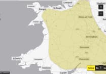


"During the early hours of Monday winds will turn westerly and affect a wider area of southern Scotland and northern England, before easing through the morning."
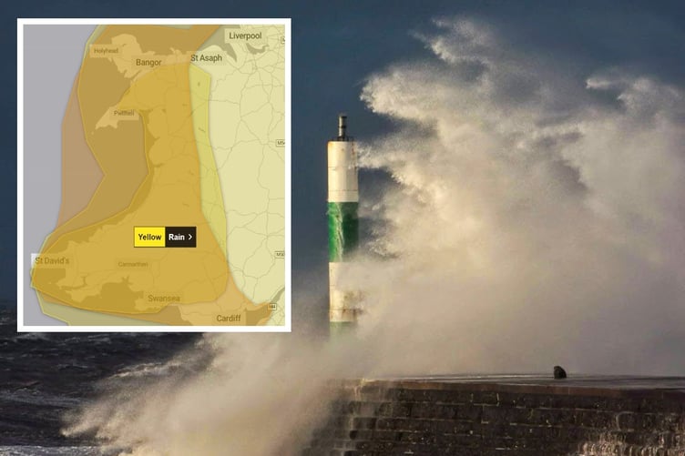
There are also yellow warnings in place on Sunday across west Wales for wind and heavy rain.
The rain warning runs from 6am Sunday until 6am Monday and states: "Spells of heavy rain, combined with strong winds at times, will move across Wales over the weekend and into early Monday.
"The heaviest rain is expected over hills during Sunday with 20-50 mm falling widely and the potential for peaks of 80-100 mm, most likely over Eryri.
"Milder conditions will also result in the thaw of lying snow."
Ceredigion County Council is advising people not to make unnecessary travel on Sunday when Storm Isha hits.
A council spokesperson said: "Ceredigion residents and visitors are advised to be safe and not make unnecessary journeys during the weather warnings.
"The public are reminded to be careful whilst travelling as the winds may result in fallen trees and debris being present on the highway.
"The public are also asked to be vigilant in relation to the potential damage to buildings and other structures, resulting in tiles and other debris falling in public areas.
"The winds could also lead to power cuts and affect council-run services."
Chief Meteorologist, Dan Suri, said: “Storm Isha will bring strong winds to the whole of the UK through Sunday and into Monday. The areas of particular concern are reflected by a large Amber severe weather warning which covers Northern Ireland, central and southern Scotland, Wales, much of northern England as well as southwestern parts of England.
“In these regions we could see gusts frequently between 50-60mph and even up to 80mph in exposed coastal locations. As the storm starts to move away on Monday morning very strong winds will also develop in the far southeast of England, bringing the risk of 70-80mph gusts here too in the early hours of Monday morning.
“Storm Isha will bring a disruptive spell of weather to the UK with strong winds across the whole country. Heavy rain will cause additional hazards, particularly in the west. A number of severe weather warnings for rain have also been issued."
Warnings highlight the possibility of travel disruption, power cuts and dangerous conditions near the coast with high waves and flying debris.
A spokesperson for Energy Networks Association, which represents Britain's energy network operators, said: "An amber warning brings an increased risk of damage to homes and vital infrastructure. Energy network operators are preparing to deal with any damage quickly and safely.
"With severe weather forecast, our advice to customers is to prepare, care and share. Prepare by going online to PowerCut105.com for advice and call 105 for free if you have a power cut.
"Check in with people who might need extra help, and share this information so friends and family know what to do too.
"If you see damaged power lines or lines brought down over the coming days, stay well clear and call 105 for free to report it, or dial 999 if there’s an immediate danger to life."
Next week
The winds will gradually ease through the day on Monday. Overnight into Tuesday will be a calmer interlude for most, with lighter winds and fewer showers in the north for a time.
This does not last for long, however, as low pressure brings further wet and windy weather from the west on Tuesday morning, spreading eastwards across the UK though the day.
Further into next week there are signs that conditions will settle down in the south, with any wet and windy weather becoming more confined to the northwest of the UK. Temperatures are expected to remain mild for the time of year.
Comments
This article has no comments yet. Be the first to leave a comment.