A joint project between agencies in Wales and Ireland is looking at the ancient ties that bind communities across the Irish Sea. That shared history dates back 30,000 years ago, when vast sheets of ice covered the area. But as the ice melted, our ancient ancestors began to take the first steps towards Cardigan Bay. ALEX BOWEN reports
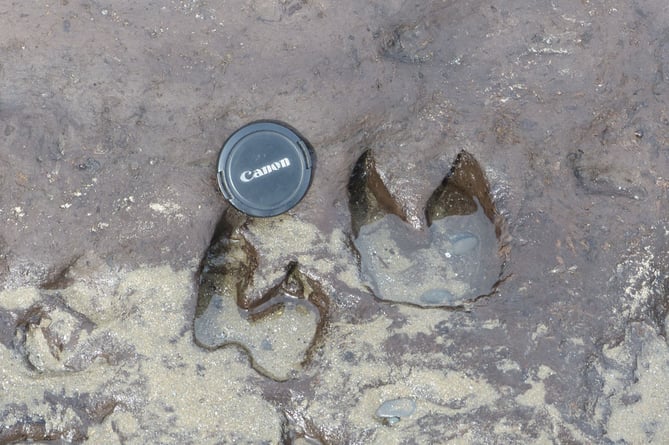
They are barely four inches long and have likely gone unnoticed down through the millennia as nothing more than a slight indent in the multi-textured and changing surface of Borth beach.
But look carefully, and they are the footprints of a child, made in then soft clay roughly 6,000 years ago.
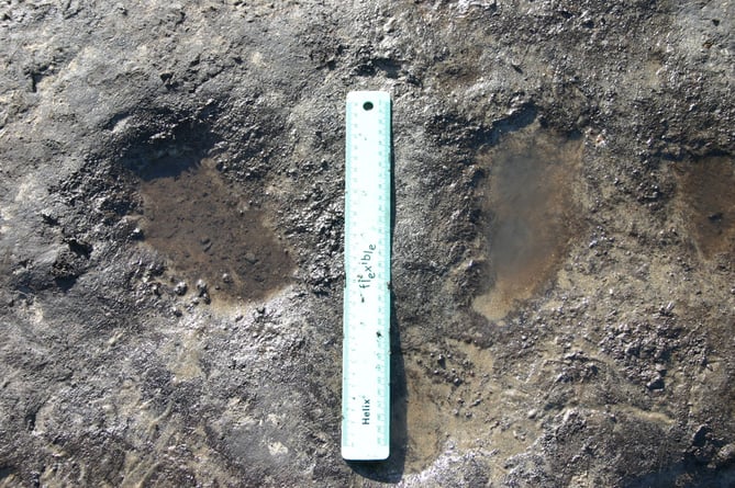


Down through the centuries, few would have noticed. But to the trained eyes now of archaeologists and those academics who seek to peel back the layers of history of this nation, the footprints along with other recent and recent discoveries, are allowing experts to build a picture of what life was like.
Though they may be part of the rock, these imprints stride history.
Dr Martin Bates is a geoarchaeologist at the University of Wales Trinity Saint David (UWTSD) and for him, the footprints are very significant indeed.
“It’s something that you have to keep coming back to,” he told Cambrian News. “It’s something that can leave you wondering ‘why do I keep coming back here to the same spot over and over.’ Until suddenly you see something you haven’t seen before, and it makes sense of things, and, in the end, makes it all payoff.”
He’s also one of the driving forces behind a month-long exhibition at the Borth station museum into the history of the area, and how the landscape of Wales as we know it emerged from the Ice Age, roughly 30,000 years ago.
Dr Bates and his work is all part of the wider Portalis project, which is a combined initiative between UWTSD, Ceredigion County Council, and the Waterford Institute of Technology and Waterford Chamber of commerce in southeast Ireland.
The project seeks to uncover and explore the earliest connections between Ireland and Wales, building a common narrative across the Irish Sea.
The project hopes to map the first human journey between the two countries, giving an insight into the challenges such an adventure must have posed. Already, their discoveries are revealing more about the hardships our early ancestors faced in their day to day lives as they gathered food to eat and resources to build shelter, tools, and clothes. And to do this in a landscape undergoing an array of immense and unique changes.
The project, which is funded by the European Union, is working to building cultural ties and a tourism network. Waterford Museum of Treasures in the city founded by Vikings and famed for its crystal glass, and the Ceredigion Museum in Aberystwyth, will be hubs in building that network.
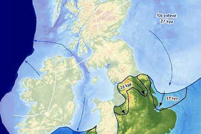
This Welsh Irish connection across the Irish Sea can be traced back 30,000 years to the end of the Ice age, where the entirety of Cardigan bay and most of Wales itself were completely covered by sheets of ice half-a-mile thick. The incredible weight of that ice lowered Cardigan Bay by some 80 feet, researchers say.
That ice sheet also carved out the network of valleys and hills of Wales and the rest of the United Kingdom and Ireland.
After the ice gradually receded, our earliest ancestors began to venture into these new lands, living a hunter-gathering existence for millennia, and then gradually making the transformation to a more settled lifestyle – growing, cultivating, building, domesticating cattle and other animals.
While we now experience life and change at a far faster pace — remember life before the internet? — the change from a roaming lifestyle to that of settled, took thousands of years.
Small bands of people walked across a new and wild landscape, beginning to set down foundations of permanent shelters than would shield them from the elements.
Not only were their own lives entirely different from ours, but the ground beneath their feet looked unimaginably different too. Archaeologists and other experts estimate that the first settlers in this region of Wales came around 8,000 years ago.
When that giant ice sheet melted, it left a landscape that would have been ground down to bare rock, taking thousands of years then for vegetation to gradually take hold.
Dr Bates says that when those immense ice sheets began to melt and its enormous weight began to lift, so too did the ground it weighed down for over 90,000 years. Even when the earliest settlers around Cardigan Bay stood upon it, the weight of those ice sheets could still be felt in the ground. It still is today, and the land beneath our feet is still “readjusting”.
Discoveries such as the red bones found in Paviland on the Gower Peninsula date back some 33,000 years.
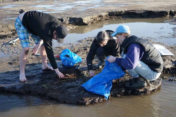
Four months into the Portalis project and experts are discovering sites that are “really interesting”. Near Talsarn, in a valley some eight miles inland from Aberaeron, archaeologists are investigating an infilled glacial lake and a collection of dry islands.
What was surprisingly unexpected about the site, was that it appeared to have been a transitional spot in human history, where hunter gatherers switched to agriculture roughly 6,000 years ago.
Much of the ground is shallow and prone to disturbances that might damage or even destroy anything buried in the ground, the team managed to carefully excavate many artifacts from the site. These included microliths — sharp stone tools often used as spear or arrow heads.
Dr Bates believes the Talsarn site to have once been a hunting ground, one where people gathered to hunt and catch fish, likely with tools crafted with those microliths.
The digs have proven promising so far, with the team finding signs of human activity on both dry islands they conducted digs on, It’s a good sign the team will find more when they excavate in the future.
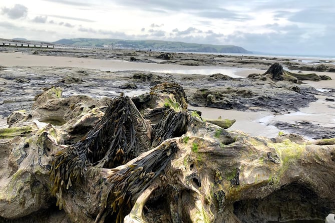
The submerged forest at Borth is another promising site of interest to the Portalis project and is the focus of the current exhibition. It’s here in the petrified trees and rocks that the discovery of those child’s footprints was found.
Dr Bates, who grew up around the area, spent much of his childhood on the beach, knowing of the forest’s existence. His father was part of the team responsible for the discovery of an auroch’s skeleton there in the 1960s. Auroch are believed to be an extinct species of cattle-life beasts, believed to be the ancestor of the modern cow.
While Dr Bates and many locals knew of the forest, it was only after a storm in 2014 that the forest began to show itself clearly, allowing he and other geoarchaeologists a rare opportunity investigate fully.
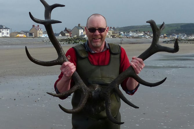
The most recent of these new discoveries were the spectacular and astonishingly well-preserved antlers of a deer, carbon dated to be around 3,000 years old.
Stretching four feet, these amazing antlers were said to have come from a very large, mature male red deer. The discovery was even more surprising as the animal appeared to have lived about some 6,000 years after the forest was thought to have submerged.
Julien Culham and Sharon Davies-Culham were the couple who first made the find back in early April 2016, noticing the antler’s distinctive and powerful shape even as they reached out from under their feet. What makes these finds even more incredible is that they are found on a beach that feels the full weight of a storm when one hits, ripping up the sand and spitting it out as it pleases.
Another payoff of tireless searching was the discovery of a set of burnt logs on Borth beach, arranged into an oval shape, an ancient clue to those who first settled these lands. These is no sign of cooking taking place near the site, so could the fire have been used for ritualist or ceremonial purposes?
The findings seem to suggest that much of the region was covered in a luscious forest of pine, birch, and oak. While handy for hunting, much of the land is believed to have been too wet for agriculture and related settlements
When asked about recently discovered maps of the Cardigan bay showing two islands out in the sea off the coast of Ceredigion, reigniting the legend of the fabled Cantre’r Gwaelod, Dr Bates said he had seen no topographic evidence supporting the existence of such landmasses.
He said scientific mapping of the area, which used bathymetry and sub-bottom profiling that viewed the physical layout of the ground beneath the sea — did not find any sign of landmasses that would fit the depiction of these islands on the 13th Century map.
Dr Bates said he saw no reason why the legend should be dismissed.
It’s a great story and we shouldn’t look for a deeper meaning,” Dr Bates says, adding that “science often tries to indulge or validate the stories and mythology that write our history, but that the two have their own individual places and values, and can make that contribution without needing to justify themselves through one and other”.
What is definitely clear is that Cardigan Bay offers an ever-increasing catalogue of both scientific and mythological history, painting a clearer picture of what it meant to live in a Wales we would not recognise.
The exhibition in Borth ran throughout august on Tuesdays, Wednesdays, Thursdays and Saturday and ended on Saturday, 3 September. Don’t worry if you missed it — the discoveries are now moving to Ceredigion museum in Aberystwyth.
The Portalis project work will also be featured in a new exhibition planned for the spring.
TIMELINE
The above map, produced by the University of Sheffield, shows how much of Britain and Ireland was covered by ice some 27,000 years ago.
- 120,000 years ago
An ice sheet a half-mile thick covered most of the British Isles.
- 33,000 years ago
Ochre-tinged bones found in a cave on the Gower Penninsula. The area wasn’t covered in ice.
- 15,000 years ago
Ice starts to retreat, with the first evidence of human habitation is caves in northern Wales.
- 8,000 years ago
Ice retreated fully, but the weight of the ice had lowered much of Cardigan Bay by some 80 feet.
- 6,000 years ago
A child left footsteps in the mud of a forest near Borth.
- 3,000 years ago
An elk or large red deer leaves antlers in Borth, discovered in 2014.
- 2,500 years ago
Many areas around Cardigan Bay were settled, with Bronze Age inhabitants living in small communities, crowing crops and keeping domesticated animals.