FRESH weather warnings for more strong winds has been issued for Tuesday evening as Storm Isha subsides.
The weekend storm left hundreds of homes without power with gusts of 90mph recorded at Capel Curig in Eryri and 89mph in Aberdaron.
There are currently 18 flood alerts and one flood warning in place, mainly on the Llyn Peninsula and inland, away from the west coast.


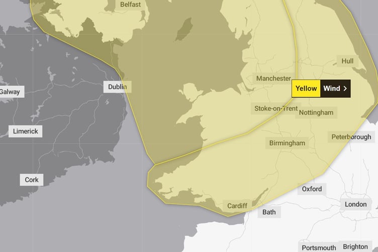
An amber warning for high winds has now been lifted, with a yellow warning in place for the entire United Kingdom until midday today (Monday).
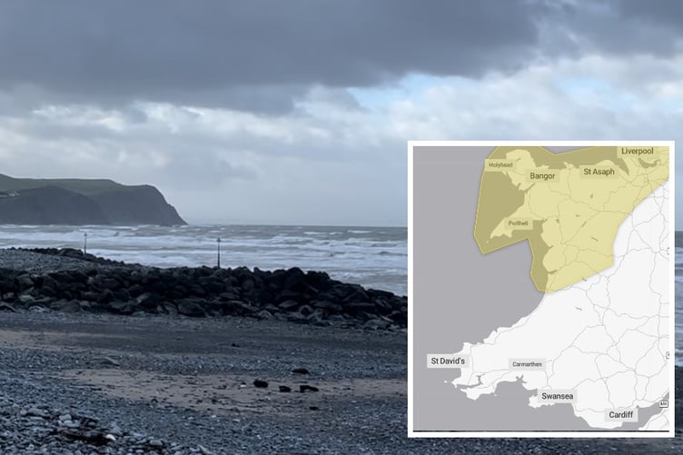
A fresh warning has been issued for Tuesday afternoon at 4pm until Wednesday at 1pm for more strong winds.
The warning area covers Gwynedd and as far south as Aberystwyth, which could bring further travel disruption and some damage to buildings.
The warning from the Met Office says: "A spell of strengthening west or southwesterly winds is expected to affect Northern Ireland, north Wales, northern England and Scotland from Tuesday evening, associated with Storm Jocelyn. Winds are widely expected to gust to 55-65 mph, with a few exposed locations possibly seeing in excess of 70 mph, although the greatest likelihood of these is now highlighted with an Amber warning.
"Gusts of 55-65mph are fairly typical for a winter storm across these areas, but following the impacts caused by Storm Isha resilience is expected to be lower and it may also hamper any ongoing recovery and repair efforts."
A second yellow warning is also in place between midday Tuesday and 3pm Wednesday for south of Aberystwyth.
This warning reads: "A spell of strong winds associated with Storm Jocelyn is expected to develop across this region during Tuesday afternoon, peaking overnight into Wednesday morning, before easing across most areas by midday. However, winds are likely to remain strong across and just to the east of the Pennines until early Wednesday afternoon.
"Peak gusts of 45-55mph are likely inland, perhaps 65mph on some exposed coasts."
Met Office Chief Meteorologist, Steve Willington, said: “Although this system will be a step down relative to Storm Isha, with the damage and clean up still underway, we could potentially see more impacts from Storm Jocelyn.
“Outbreaks of heavy rain on Tuesday could bring rainfall accumulations of 15 to 20 mm quite widely with 40 to 50 mm over higher ground in southwest Scotland, the Scottish Highlands and parts of northwest England. Wind gusts are expected to reach 55 to 65 mph across northwestern Scotland while there is potential for winds to gust to 75 to 80 mph in a few places, in particular exposed parts of the Western Isles and coastal northwest Scotland early on Wednesday morning.”
The winds will gradually ease through the Wednesday and as we head through the rest of the week the weather continues to look changeable, with the drier and most settled conditions towards the south and east, and the most unsettled (wettest and windiest) conditions expected in the northwest.
Temperatures are expected to remain mild or close to average for the time of year.
Comments
This article has no comments yet. Be the first to leave a comment.