
Experts have compiled an extensive catalogue of over 600 sites of historical interest in Aberystwyth - we took a look and have picked out our top five.
The Royal Commission on the Ancient and Historical Monuments of Wales has been working on the Coflein project, which aims to compile an online database for the National Monuments Record of Wales - the national collection of information about the historic environment of Wales.
The name is derived from the Welsh cof (memory) and lein (line).
In total, 657 sites in and around Aberystwyth have been identified as part of the research, all of which can be viewed here.


Boasting of an Iron Age hillfort, ruined medieval castle, Gothic and Neo Gothic architecture, Victorian and Edwardian buildings, funicular railway, museum, the National Library of Wales, Ceredigion Archives, a harbour, Celtic crosses and not forgetting the Royal Commission on the Ancient and Historical Monuments of Wales, Aberystwyth is undoubtedly home to some of the best historical sites in west Wales.
Here are five of the most historical sites in Aberystwyth.
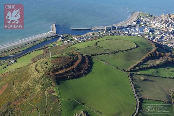
Pen Dinas hillfort
Pen Dinas, the largest Iron Age hillfort in Ceredigion, occupies an exceptional position on a coastal hill, which rises towards the western end of a long ridge separating the valleys of the Rheidol and the Paith.
Its location is optimal, one of the strongest and most readily defensible hills in the region.
This coastal hill boasts precipitous slopes on its seaward (western) side and along the south, but is approached by more gradual slopes across a lower lying saddle of ground to the east and north-east.
It sits at the coastal confluence of the rivers Rheidol and Ystwyth, allowing exploitation of a variety of resources within easy reach, including marine resources, seaweed, river fish, good grazing land and soils suitable for arable cultivation.
The fort is prominent from many miles around, and was crowned in the 19th century by the Wellington Monument.
The hill of Pen Dinas has two summits, a lower, broader summit to the north, and a higher, more narrow summit to the south. These are linked by a saddle of lower ground known as the isthmus.
Excavations by C Daryll Forde between 1933 and 1937 investigated only limited parts of the fort, but four main phases of development were established.
The fort started life as a simple defended site on the north summit, enclosed by a rampart of packed rubble and an outer ditch (Phase I).
Some years later after the first was abandoned, perhaps around 400-300BC, a new fort was built on the higher summit to the south with elaborate gates and a substantial stone-walled rampart with an outer ditch (Phase II).
After some time, this fort fell into partial ruin while parts of it were burnt.
The fine south gateway collapsed and became forgotten and overgrown.
Later, the south fort was reoccupied with new defences built and old ones extensively repaired (Phase III).
Finally, additional ramparts were constructed across the isthmus linking both summits, together with a new main gate (Phase IV).
At its height (in the last decades before Christ), Pen Dinas was a masterpiece of Iron Age architecture and engineering.
The stone-walled isthmus gate stood as high as a two-storey building and was crossed by a wooden bridge supported on four massive timber posts.
Plascrug Tower
The tower, which sat on the site of what is now Ysgol Plascrug primary school, is said to have been a stone embattled tower which was attached to a 17th century manor house.
The tower is thought to have been a folly, but one which sat on the remains of a much older Castle Rheidol.
As part of the works to build an extension to Plascrug school, archaeologists revealed a fascinating structure, which was actually under the existing school building.
Historical documents (Brut y Tywysogion) dating back to the 12th century talk about storming and burning a castle called Aber-rheidol in 1164.
Although we don’t know where this castle was, it is widely believed it might have been on the site of the school.
Before the school was built, there was a farmstead on the site, and there are lots of paintings, drawings and early photographs to show what it looked like.
It was a fortified mansion, with a square tower. The tower was quite famous during the late 18th and early 19th centuries, and was an attraction for people sightseeing in the area.
Dyfed Archaeological Trust said in a report that a Medieval castle, presumably the Palace of Rheidol, is mentioned in a poem of 1244, which was a moated house.
An old print (Henry Gastineau 1830) shows a small square tower of three storeys, with a first floor entry of a door with a pointed arch attached, to a small hall block, itself attached to a slightly large building.
Aberystwyth Harbour
The harbour at Aberystwyth is the outlet of the united rivers of the Rheidol and Ystwyth.
The silt/sandbar at the entrance has impacted on the port’s prosperity in times past. For example, in 1561 Aberystwyth was described as ‘a barred haven of no value’.
However, by the 18th century, it had a fleet of some 60 small sloops and smacks, with the local fisherman pursuing herring, cod, whiting, pollack and ray during the summer and autumn, and coastal trading during the rest of the year.
Trade at Aberystwyth harbour increased so much that in 1763 the Customs House was moved to Aberystwyth from Aberdyfi, and Aberystwyth subsequently became a port of registry.
In 1780, an Act of Parliament was passed to further the harbour’s development.
In 1836, measures were taken to remove the bar and improve the harbour, so that Aberystwyth could become the homeport for much larger vessels, such as schooners, brigs and barques.
Aberystwyth was exporting materials such as lead, zinc ore and tanning bark, and importing coal, limestone, slates, flagstones, timber and household goods.
By the 1840s, trading ships were even taking passengers to North America returning with cargoes such as timber.
Aberystwyth also supported a small shipbuilding industry - rope and sail-makers as well as the timber yards and a large saw mill. The total number of ships built at Aberystwyth has been reported as 242.
These were primarily the work of three generations of the Evans family; Faulk Evans, his son John and his grandson, John Faulk Evans.
Admiralty Sailing Directions dating to 1870 noted that Aberystwyth was the homeport for 359 vessels with a tonnage of 39,235 tons.
The number of shipping movements in and out of the port in 1868 were 400. It describes the entrance to the harbour as ’defended south-westerly by a pier 260 yards long, extending in a north-northwest direction.
The importance of Aberystwyth harbour diminished with the introduction of the railways in the 1860s.
The railway provided an alternative route for imports and exports and, as a result, sea trade decreased rapidly. Also, Aberystwyth harbour had insufficient deep water to cater for steam or motor cargo vessels of ever increasing size.
Throughout much of the 20th century, Aberystwyth harbour was home to a small fleet of lobster fishing vessels. With the development of the marina in 1990s, the harbour now shelters an increasing number of leisure craft.
Aberystwyth Castle
Work on Aberystwyth Castle commenced in 1277 under Edward I and was completed in 1289.
It is a concentric-walled lozenge-plan castle of coursed rubble masonry.
It has a dry moat to the west and round towers to the inner and outer wards. There is an inner gate tower to the west with an outer gate beyond.
The twin apsidal tower gateway has a pointed entrance, portcullis chase, crenellated parapet and splayed stair turret. There is a dungeon to the southwest and a mural tower on the south side of the inner ward.
Aberystwyth Castle also had its own Royal Mint, which was established by Thomas Bushell in the castle hall in 1637.
Circa 1790 the ground in front of the castle was laid out in a series of walks by John Probert.
The site is now partly covered by St Michael’s Church.
Aerial reconnaissance in 2001 noted earthworks of parallel ridges in the western end of the castle, between the moat and the war memorial. These are possibly cultivation ridges, gardens or even allotments.
Early Medieval Crosses, St Padarn’s Church, Llanbadarn Fawr
Two stone crosses are the only pre-Norman relics which have survived in the church at Llanbadarn Fawr.
They once stood in the churchyard on the south side of the church until 1916 when they were brought inside and placed in the south transept.
They were moved to their present position in 1987.
Precise dating of the crosses is difficult, but it is now believed that they may well be reused pre-Christian standing stones.
The large cross is made from granite, possibly from the Llyn Peninsula, and is one of only a few Welsh crosses to include figurative carving as well as the typical interlacing which was developed by the Christian Celts.
Learn more about the history of the town and explore all 657 historical sites by visiting the Royal Commission on the Ancient and Historical Monuments of Wales website
Comments
This article has no comments yet. Be the first to leave a comment.