
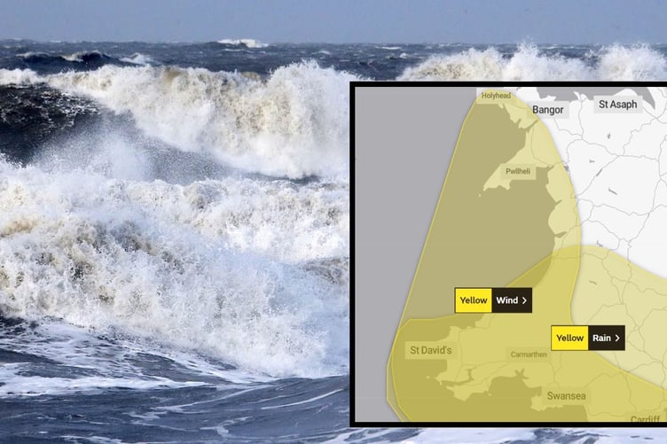
TWO weather warnings are in place for west Wales later this week as Storm Ciarán approaches
Heavy rain and 'very strong' winds are likely to cause disruption on Wednesday and Thursday according to the Met Office, which has issued two yellow warnings.
The warning for strong winds, which covers the entire west coast of Wales, runs from 9pm on Wednesday through to midnight on Friday.
The Met Office says: "Winds are expected to gust 50-60 mph along coasts, and may reach 70-80 mph at times along the English Channel coast of England as well as north Cornwall.


"There is a very low likelihood that of gusts up to 90mph could affect the far west of Cornwall and the Isles of Scilly.
"Inland, gusts are likely to reach 40-50 mph at times, with a possibility of 60-70 mph gusts over high ground such as Dartmoor. Very large waves could bring additional impacts to coastal areas, especially parts of west and south Wales, and southern England."
There is a slight chance the winds could damage homes, cause power cuts and bring travel delays.
The warning for heavy rain runs from 6pm Wednesday until midnight Friday, but only stretches as far north as Aberystwyth.
The warning says: "Periods of heavy rain, associated with Storm Ciarán, are expected to affect much of southern Britain from Wednesday evening and during Thursday.
"A further 20 to 30mm is likely quite widely, but 40-60mm may accumulate in places, especially, but not exclusively, over higher ground. Given this amount of rainfall, the current saturated conditions, and the potential for fallen leaves to block drains etc - further impacts are likely."
Met Office Deputy Chief Meteorologist, Chris Almond, said: “Winds associated with Storm Ciarán are likely to gust to 80mph along the south coast of England, with a small risk of somewhere exposed seeing 90mph, and winds could even gust up to 50 or 60 mph further inland.
“This deep low-pressure system will also bring heavy rain to much of the UK, but the heaviest rain is expected in southern and western areas with 20 to 25mm quite widely across the region but up to 40 to 60mm potentially over higher ground. Heavy and persistent rain will fall onto already saturated ground bringing a risk of further impacts such as flooding in areas that are already struggling to clean up from the heavy rainfall we have seen over the last week or so.”
Comments
This article has no comments yet. Be the first to leave a comment.