

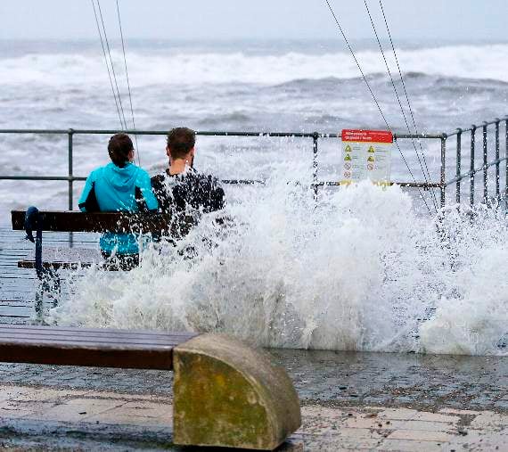
EXPERTS are warning people living in coastal areas of Wales to be prepared to see localised flooding as Wales prepares for Storm Brian.Large swathes of Wales have been issued with a yellow weather warning just days after ex-hurricane Ophelia swept through the country.Storm Brian is expected to hit mainly coastal areas on Saturday and the Met Office has issued a yellow weather warning for between 4am and midnight.Natural Resources Wales (NRW) is warning people that parts of the Welsh coast could see localised flooding as Storm Brian combines with high tides this evening and tomorrow.The conditions could cause a storm surge, which in some areas could lead to overtopping of sea defences. Current predictions show that the worst affected areas are likely to be along exposed sections of the west coast of Wales from Southern Gwynedd to Llantwit Major.Ceredigion Council announced on Friday afternoon that it will be closing Aberystwyth promenade and Quay Parade in Aberaeron tomorrow morning and evening at high tide.In a statement, the council said: "Marine Terrace, Victoria Terrace and New Promenade car park in Aberystwyth and Quay Parade in Aberaeron will be closed for approximately three hours on Saturday, 21 October during high tide at 9.27am and also at 9.42pm."This means that the closures will be in effect from 8am and will run until 11am in the morning and 8.12pm and 11.12pm in the evening.A spokesperson for Ceredigion County Council added: "Residents are being asked to stay away from these areas during those times, and to be careful on beaches, promenades, coastal footpaths, roads and low lying land where coastal flooding is possible."NRW has issued a number of flood alerts for the west coast, and is likely to issue flood warnings for Aberystwyth and Newgale.Further alerts or warnings for other areas will be issued as necessary.24/7 Emergency response workers from NRW will be out at key areas of the coast over the next couple of day to monitor the high tides and condition of its sea flood defences.NRW has also contacted its partner agencies such as local councils and the emergency services to ensure that appropriate responses are in place should the need arise. Richard Hancox, from Natural Resources Wales said: “Conditions across the coastline are likely to be extremely dangerous this weekend and we urge people to stay clear, and avoid visiting the coast during this time.“We know people are tempted to try and take photos of these storms, but it really isn’t worth putting your life at risk. Sea spray and flood water can knock you off your feet easier than you might think, and the large waves can send debris flying onto shore.“If anyone is concerned about the risk of flooding to their home, please check to see if flood warnings are available in your area, and visit our website for advice on how best to prepare.”Flood alerts and flood warnings are updated on the Natural Resources Wales website every 15 minutes.The Met Office warns: “A spell of strong southwesterly winds is expected.“Some coastal routes and communities are likely to be affected by large waves, with potential for flooding of properties. “Some transport disruption is likely across the warning area, with delays to road, rail, air and ferry transport. “Short term loss of power and other services is also possible.”

The chief forecaster’s assessment adds: “The winds initially southwesterly will gradually turn westerly later whilst also slowly easing.
“Gusts exceeding 50 mph are expected widely within the warning area, with gusts of around 70mph along exposed coastal areas.
“These are expected to coincide with high tides, leading to locally dangerous conditions around the coast.”Arriva Trains Wales and Network Rail have already agreed to implement emergency speed restrictions across most of the routes across Wales and the borders. This will result in significant changes to most Arriva Trains Wales services for the majority of the weekend. Customers should ensure they use www.jounreycheck.com/arrivatrainswales before they travel in order to check how their services may be affected. Lynne Milligan Customer Services Director for Arriva Trains Wales, said: "Storms can be incredibly dangerous for the railway in that they can result in debris falling on to the track, flooding and other risks. "In order to keep our people and our customers safe, we have had to take the difficult but necessary decision to make significant changes to our timetable. These changes could include changes to train time, reduced carriages on some services or cancellations. "We will be doing everything we can to keep customers moving safely, but it is really important the customers check before they travel. Whilst we have made every effort to operate as normal a timetable as possible, as well as providing alternative options with bus and other rail operators, we know that customers are likely to affected if they do not plan ahead before they travel."Bill Kelly, Chief Operating Officer for Network Rail in Wales and the borders, added: "With severe weather expected over the weekend, we have put emergency speed restrictions in place to ensure the safety of passengers."We are monitoring the weather closely and have additional response teams on standby to keep the railway clear and safe."The Conwy Valley Line will also be closed for three weeks while we repair the damage caused by Storm Ophelia"We are working closely with our partners at Arriva Trains Wales to keep passengers moving, but advise people to check before they travel."Information and updates are also available by calling Floodline on 0345 988 1188. People can also register for free flood warnings either by calling the Floodline number or at NRW’s website.
Comments
This article has no comments yet. Be the first to leave a comment.