
The Met Office has issued a warning of potential 70mph winds and 100mm of rain across parts of Wales from Monday evening onwards.
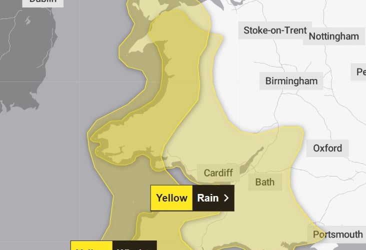
Yellow warnings have been issued from 6pm Monday evening and run into Tuesday for wind and rain across much of the country.
The rain warning begins at 6pm on Monday and runs until 2pm Tuesday, with the Met Office saying up to 80mm of rainfall is possible in high ground across Wales.
The warning says: "Outbreaks of rain will become persistent and heavy on Monday night into Tuesday morning.
.png?width=209&height=140&crop=209:145,smart&quality=75)
.png?width=209&height=140&crop=209:145,smart&quality=75)


"There will naturally be some variation in rainfall totals across the area, but accumulations of 20-40 mm are likely in quite a few places, with 60-80 mm over Dartmoor and high ground in Wales. "There is a chance of up to 100 mm falling over the most exposed, prone hills.
"Given the saturated nature of the ground, this is likely to lead to some flooding in places and transport disruption. Rain will also be accompanied by strengthening southerly winds, which may exacerbate impacts."
A second warning for strong winds comes into force from 10pm on Monday and runs until 4pm on Tuesday.
This warning states: "South to southwesterly winds will strengthen on Monday night and remain strong and gusty into Tuesday morning, before gradually easing through Tuesday afternoon.
"Peak gusts of 40-50 mph are expected fairly widely, but gusts of 60-70 mph will be possible along some exposed coasts and over/to the north of high ground.
"There is a small chance of gusts in excess of 70 mph over northwest Wales."
A flood alert has also been issued for the coast between Cardigan and Clarach.
Natural Resources Wales says: “The risk of flooding as a result of the combination of the high tides and weather conditions is expected to continue for the morning tide on Monday the 8 December through until the evening tide on Tuesday the 9 December.
“Flooding of low-lying land and roads is expected around the periods of each high tide. Impacts are currently expected to be greatest for the tides on Tuesday, as a new storm system is expected to bring large waves.
“Be careful on beaches, coastal footpaths, roads, and low lying land close to estuaries. Wave overtopping is possible at the most exposed coastal sites. We will continue to monitor the situation. We will update this message if the situation changes.”
An amber warning has also been issued for parts of Scotland as Storm Bram approaches.
Met Office Chief Forecaster, Dan Suri, said: “Storm Bram will bring a very wet and windy spell of weather, with very strong winds and further heavy rain which falling over saturated ground, could cause flooding impacts. Within the Amber wind warning over northwest Scotland, gusts of up to 90 mph could be recorded. More widely, gusts of 50-60 mph, and perhaps 70 mph in a few spots, are expected across Wales, southwest England and Northern Ireland.
“Rain is an additional impact from Storm Bram, with the possibility of 100mm over higher ground in the south of Wales and parts of Devon. This could require escalations to existing warnings, so it’s important to stay up to date with the forecast in your area, as well as any flood warnings from your local environment agency.”
Staying safe in a storm
There are steps you can take to protect yourself and your property during a storm. These include:
- Securing loose objects such as ladders, garden furniture or anything else that could be blown into windows and other glazing and break them
- Closing and securely fastening doors and windows, particularly those on the windward side of the house, and especially large doors such as those on garages
- Parking vehicles in a garage, if available; otherwise keep them clear of buildings, trees, walls and fences
Weather for the rest of the week
It will be notably mild for the time of year, with highs on Tuesday reaching 16°C or so in parts of north Wales, northwest England and southern Scotland. Temperatures will fall closer to average for the time of year later in the week.
Storm Bram will slowly pull away northwards from Britain during Wednesday. In its wake, Wednesday will be a windy day, especially in the north, with some showers, mainly in the west as well as some more persistent rain in the far north, at least at first.
Thursday will be a drier day for many across the UK, with the chance of a frost for some in central and southeastern parts to start the day. It will remain very windy in the far north, with low cloud, drizzle and eventually rain moving in from the West.
Comments
This article has no comments yet. Be the first to leave a comment.