

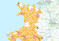
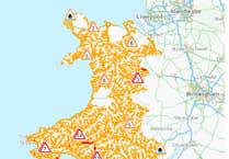
The Met Office has issued a yellow weather warning for the west coast of Wales on Thursday.
Forecasters say a spell of strong northwesterly winds will develop across parts of southwest England and western Wales on Thursday.
Gusts are expected to reach 40-45 mph widely across the warning area, with a risk of these reaching 50-60 mph along exposed coasts and headlands.
The warning runs from 4am until 6pm on Thursday, 23 October, with the Met Office warning the winds could cause some disruption.


There are three yellow weather warnings in place for different parts of the UK on Thursday, with rain expected to hit the midlands and winds in the southeast.
The warning for west Wales adds: "It’s likely that some coastal routes, sea fronts and coastal communities will be affected by spray and/or large waves."
The Met Office adds: "If you are on the coast, stay safe during stormy weather by being aware of large waves. Even from the shore large breaking waves can sweep you off your feet and out to sea. Take care if walking near cliffs; know your route and keep dogs on a lead. In an emergency, call 999 and ask for the Coastguard."
The warning area includes Ceredigion, Pembrokeshire, Gwynedd, Carmarthenshire, Anglesey and parts of Swansea and Conwy.
Deputy Chief Meteorologist, Dan Harris said: “Low pressure moving across the south of the UK on Thursday will bring both a spell of heavy rain and areas of strong winds.”
“The rain is expected to arrive from the southwest during Wednesday evening, before spreading northeast to many parts of England and Wales during Thursday, leading to difficult driving conditions and the risk of flooding in a few places. At the same time, winds are expected to pick up along south coastal areas in particular. However, it is not until Thursday morning that significantly strong northwesterly winds will first begin to affect parts of the west with gusts of 45 to 55 mph, locally 65mph around coasts expected. A little later, northerly winds are expected to develop more widely across eastern areas, most likely of similar strength, but there is a small chance of gusts in excess of 70mph should the low pressure system end up being at the stronger end of expectations”.
“It is worth noting that there is a greater than usual uncertainty surrounding the track and intensity of this low-pressure system, so the public should stay up to date with the latest forecasts and warnings as the situation evolves, with adjustments to the forecasts likely at short notice."
Away from the warning areas Thursday will widely be a wet and windy day across England and Wales before sunny spells and blustery showers develop. Temperatures will be near normal but feel rather cold in the north westerly winds.
Friday will be a day of sunny spells and heavy, blustery showers for many. These will gradually ease later in the day, although winds will remain strong, with coastal gales likely, particularly in the east and northeast.
It will turn colder over the weekend as an Arctic Maritime airmass spills southwards in the wake of the mid-week low pressure system. There will be a mix of sunny spells and blustery showers which are likely to be wintry over mountain tops in Scotland; this is fairly typical for this time in the year. Sunday may offer a brief window of drier and brighter conditions.
Comments
This article has no comments yet. Be the first to leave a comment.