

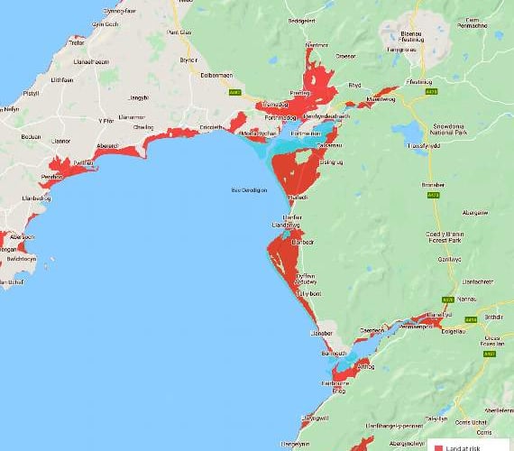
A worrying map has revealed the areas of Dwyfor and Meirionnydd most at risk of flooding due to rising sea levels.

.png?width=209&height=140&crop=209:145,smart&quality=75)
.jpeg?width=209&height=140&crop=209:145,smart&quality=75)

A number of coastal towns and communities in Gwynedd are set to be affected by rising sea levels according to the map, created by Climate Central, an independent organisation of scientists and journalists based in America.
Among the areas to be affected by rising sea levels within the next 50 to 100 years is Fairbourne, which has already received national attention since it was confirmed its sea defences would not be maintained after 2054. Tywyn, Harlech and Pwllheli are also among the affected communities shown on the map.
A spokesperson for Natural Resources Wales said: “The science behind climate change is showing that we can expect significant sea level rise and more extreme weather events in the future.
Gwynedd councillor Hefin Underwood said: “We do see more rain these days and flooding is a lot more frequent. Most of my ward is on a flood plain, as is most of Pwllheli. I’ve seen flooding over the last few years.
“In coastal towns, such as Pwllheli, it is getting pretty precarious.”
Comments
This article has no comments yet. Be the first to leave a comment.