

FORECASTERS have added another weather warning for snow later this week.
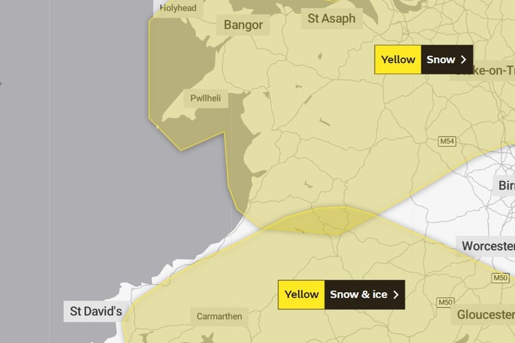
The Met Office has today added a warning for snow and ice across south and mid Wales on Wednesday and Thursday, which leaves most of Wales covered by a warning, excluding coastal parts of Ceredigion and Pembrokeshire.
The new warning for snow and ice runs from midnight Wednesday until 9am Thursday.


.png?width=209&height=140&crop=209:145,smart&quality=75)

The Met Office says: “An area of rain, sleet and snow is expected to develop over southwest England during Tuesday evening and move east during early Wednesday before clearing mid-morning.
“Whilst drier conditions may develop for a time through the middle of the day, a further spell of sleet and snow is likely to develop during the afternoon and move east into the evening. “There remains significant uncertainty in how far north snow develops as well as whether accumulations are focused mainly over higher ground.
“At this stage, the focus for the higher snow accumulations is across England south of the M4 during later Wednesday where there is a chance that some places could see 5-10 cm falling in a few hours.
“Earlier in the day and across the wider warning area, accumulations are expected to be lower, typically 1-3 cm.
“As snow clears on Wednesday night, clearing skies will result in ice developing on untreated surfaces with impacts lingering into Thursday morning.”
A yellow warning for snow in the north of Wales and northern England comes into effect at 3am on Thursday and will run until 6pm Friday.
The Met Office says of this warning, which covers all of Gwynedd and stops just south of Aberystwyth: “Snow could develop quite widely across the warning area through Thursday and Friday as a potentially deep area of low pressure moves across the UK.
“Parts of Northern Ireland, north Wales and northern England are currently expected to see the worst of the conditions develop from early on Thursday, with parts of Scotland and northern England then seeing snow arrive from Thursday afternoon.
“Snow across central and northern areas will and persist through much of Friday, while across the southern portion of the warning area, snow will turn back to rain through Thursday afternoon and evening.
“Event totals could bring 3 to 5 cm widely across this area, with 5 to 10 cm of snow across broad areas, even at low elevations, with potentially 15 to 20 cm accumulating across the central and northern areas. Higher elevations, mainly above 150m, of the North Pennines, Southern Uplands, parts of the Central Belt and the southern Highlands may see as much as 30 to 40 cm of snow in places. In addition, there is potential for strong winds, which may lead to blizzard conditions and drifting of lying snow.”
Met Office Deputy Chief Meteorologist Helen Caughey said: “The impactful weather will continue through the latter part of the week as mild air pushing in from the southwest meets colder air in situ with further snow and ice for many areas.
“Through Thursday and Friday the snow risk spreads, to central and northern areas of the UK, with the potential of some significant accumulations even to low levels, which have the potential to cause impacts. Parts of Northern Ireland, Wales and northern England are expected to see the worst of the conditions develop from early on Thursday, with parts of Scotland and northern England then seeing snow arrive through Thursday afternoon. Snow across the northern half of the UK will persist through much of Friday, while further south, any snow will turn back to rain through Thursday afternoon and evening. Strong winds are also expected to develop through Thursday and Friday which may create drifting snow and blizzard conditions in places.”
Comments
This article has no comments yet. Be the first to leave a comment.