A SECOND warning for thunderstorms has been issued for the weekend - with the potential for 40mm of rain to fall in an hour.
A plume of warm air will waft north over the weekend, bringing with it the chance of torrential rain and thunderstorms across Wales.
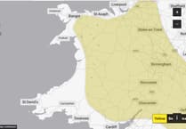
The first warning will run from 2pm until 9pm on Saturday, with the chance of 60mm of rain in some places, whilst other places will remain dry.
The second warning runs from midday until 9pm on Sunday.


The Met Office says: "High temperatures on Sunday will trigger a scattering of showers across the warning area, some of which are likely to be torrential and thundery, perhaps bringing a few places 30-40 mm in an hour.
"The odd place, affected by multiple showers, could see more than this, perhaps in excess of 60 mm in a few hours, this being most likely across Wales and central England. As well as rain, additional hazards will be hail, strong gusts of wind, and lightning will be additional hazards. Despite this, many places in the warning area will remain dry, or only see small amounts of rain, due to the scattered nature of the heaviest showers".
The area of high pressure which has been responsible for the last couple of weeks of settled weather for much of the UK will drift away towards Scandinavia, allowing a plume of warmer, humid air from the south to influence the weekend weather for much of the UK.
Temperatures will begin to climb from Friday as the warmer air pushes in from the south, bringing with it the chance of some evening and overnight showers in the southwest of England and southern Wales.
As this warmer air pushes further north and east through the weekend, temperatures will rise, triggering widespread thundery showers by Saturday afternoon and again on Sunday.
These will bring the chance of hail and gusty winds for some places, as well as torrential downpours for a few. This will be the first meaningful rainfall for many places across the UK for several weeks. As is often the case, many places will either miss the worst of any thunderstorms, some staying dry altogether, just a few locations catching the intense downpours.
Met Office Chief Meteorologist Frank Saunders, said: “Temperatures will increase into the weekend with a peak of 31°C expected on Saturday in central and southeast England. As the heat builds from the south, thundery showers will develop through Saturday afternoon and while not everyone in the warning area will see the heaviest showers, or even any rain at all, some will bring heavy thundery downpours. With intense showers there is a risk of surface water flooding which could cause some disruption – the very dry, baked ground may not help in that respect.”
Frank added: “The heat will last for a few more days at least, Sunday will see 30°C again in parts of southern UK and the risk of thunderstorms also spreads more widely across the UK – particularly western and central areas – with heavy downpours again brining the risk of thunder, hail and gusty winds. As well as higher daytime temperatures, overnight temperatures will also climb with some locations not getting below the mid-teens °C overnight.”
Further ahead
Signals for next week indicate the risk of thundery downpours will continue at first for some with temperatures likely to remain above average. Eastern coastal areas could be slightly cooler again, with a resumption of an easterly breeze.
Comments
This article has no comments yet. Be the first to leave a comment.