
The Met Office has issued a series of a snow and ice warnings for much of Wales between today (Friday) and Monday.
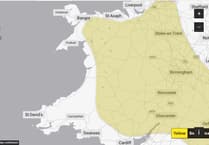
The warning area however does not cover coastal areas along Cardigan Bay.
The first yellow warning of snow and ice comes into force at 6pm on Friday and runs until 10am on Saturday.
The warning states: "Showers will become increasingly wintry on Friday evening and overnight.


"Whilst many places will not see much in the way of snow accumulations, 1-3 cm is likely in some areas, especially over higher ground. Ice will be an additional hazard on untreated surfaces."
The second yellow warning for snow and ice covers from Sunday at 3pm until Monday at midday.
This warning states: "Snow showers are expected to push further inland across Wales, parts of northwest England, the West Midlands and southwest England during Sunday evening.
"Along windward coasts, rain and sleet is more likely, but inland showers will fall as snow. Whilst not all locations in the warning areas will see snow, around 1-3 cm is expected to fall in many places by Monday morning, with the potential for 5-8 cm to build up in a few locations, particularly across inland and higher parts of Wales.
"Icy patches are likely to form widely."
Again, the warning area avoids coastal regions of Cardigan Bay.
Comments
This article has no comments yet. Be the first to leave a comment.