

Much of Wales is set to see snow, heavy rain and strong winds later on Thursday as Storm Garetti sweeps over the UK.
The Met Office has described the weather on Thursday and Friday as a 'multi-hazard' event as a deep area of low pressure heads in from the Atlantic.
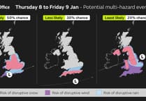
An Amber warning for wind has been issued for the west of Cornwall and the Isles of Scilly where potentially exceptionally strong winds could cause significant impacts. An Amber warning for snow has been issued for most of Wales, the Midlands and southern parts of northern England.
Numerous Yellow warnings for wind, snow and rain have also been issued across different regions of England and Wales.


Only a slither of coastal area along Cardigan bay from Aberystwyth, including the Llyn Peninsula, is outside the warning areas.
The strongest winds in the UK associated with this system are expected to affect the west of Cornwall and the Isles of Scilly where gusts could reach up to 100mph in exposed coastal locations where the Amber warning is in force.
Very large waves will bring dangerous conditions to coastal areas. These are exceptional wind speeds and could be stronger than other storms in recent memory such as Storm Ciaran in 2023 and Storm Eunice in 2022.
Strong winds, with gusts of 50-60 mph, will affect the far southwest of Wales and other parts of southern England, especially exposed coasts and hills.
Even stronger winds from Storm Goretti are expected in the Channel Islands and northern France, which is why the storm has been named by Météo-France and does not use a storm name from the Met Office storm list.
Storm Goretti is also expected to bring a spell of snow, with the largest snowfalls most likely to be across Wales and parts of the Midlands, where a further Amber warning has been issued. Rain will be an additional hazard, particularly for parts of southwest Wales and eastern England as Goretti moves through.
Met Office Chief Forecaster Neil Armstrong said: “Storm Goretti will be a multi-hazard event, with the most significant impacts from snow in parts of Wales and the Midlands and the very strong winds in the far southwest, though heavy rain in some parts of Wales and East Anglia also has the potential to bring disruption to many.
“Goretti will bring snow on its northern edge, this most likely over Wales and the Midlands. Here accumulations of 10-15 cm are likely widely, with 20-30 cm possible in some places, especially higher ground in Wales and the Peak District. An Amber warning has been issued where the greatest risk of disruption is likely on Thursday night into Friday morning. This is a complex spell of severe weather and I’d advise people in the warning areas to keep up to date with the forecast and messages from local authorities.”
Further north, cold conditions persist with a continued risk of snow and ice. Thursday and Friday will be more settled days across Scotland, Northern Ireland and the far north of England with some coastal wintry showers but brighter and drier conditions inland. Temperatures fell to -14.7°C at Tomintoul, Banffshire, overnight last night. Temperatures will once again drop overnight, widely falling below freezing and lows of -12°C or lower possible in areas of lying snow. Further warnings are likely to be issued for the continued wintry conditions.
Storm Goretti’s influence will wane on Friday evening as the system moves to the east of England. There will be a short-lived interlude of calmer weather for many on Saturday with rain showers easing, cloud for those in the east, and sunny spells possible elsewhere.
However, by Sunday further unsettled weather will move in from the west. As milder Atlantic air tries to displace the cold air over the UK it brings a risk of some further widespread snowfall and strong winds in the north of the UK and rain further south. There is still some uncertainty in the detail for the second part of the weekend so it’s important to stay up to date with the forecast.
The current outlook for next week is for the milder air to push across the UK, ending this current spell of cold weather and opening the door to temperatures closer to average for the time of year as well as further areas of low pressure bringing wet and windy spells from the west.
Comments
This article has no comments yet. Be the first to leave a comment.