

An Arctic airmass continues to cover the UK, bringing cold conditions with snow, sleet and hail showers.
Several schools are closed across Wales on Monday, with more snow forecast into Tuesday.
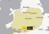
Forecasters at the Met Office say there is a chance further wintry weather will hit Wales from Thursday, along with strong winds.
It will be another cold day, with temperatures widely struggling to get much above freezing. Overnight into Tuesday temperatures will once again fall below freezing for much of the country, with the lowest temperatures over lying snow possibly dipping to -12°C.


Tuesday will see a continuation of wintry showers at first across parts of Wales and southwest England.
A mix of rain, sleet and snow will move south-eastwards across Scotland and Northern Ireland, then later into parts of Wales and England. There is a chance that a further spell of disruptive snow could affect central and northern Scotland later Tuesday morning until early evening.
Met Office Chief Meteorologist, Matthew Lehnert, said: “The UK will continue to experience a range of winter weather hazards through this week, with low temperatures as well as snow showers and the risk of ice for many. A number of severe weather warnings have been issued and these are likely to be updated through the week so do keep up to date with the forecast.”
Further into the week there are signs that strong winds and heavy rain may bring additional hazards to the impactful weather across the UK. There is some uncertainty over the position of a low pressure system which is important in understanding the potential weather hazards it may bring.
Deputy Chief Meteorologist, Mike Silverstone, explains: “While we’re confident an area of low pressure will move in from the west on Thursday and into Friday, the exact position of that low pressure is uncertain at this stage. The position is important as it will determine the type of severe weather different locations may experience.
“The most likely scenario at this stage is for low pressure to track near the south coast. Near and south of the low, heavy rain and strong winds are more likely, whilst snow could accumulate to the north as it encounters cold air. As confidence increases in the track of the low pressure, so will the detail of the weather impacts so it is important to stay up to date with the weather forecast through the week.”
The most likely scenario at this stage is for low pressure to track near the south coast. Near and south of the low, heavy rain and strong winds are more likely, whilst snow could accumulate to the north as it encounters cold air.
Comments
This article has no comments yet. Be the first to leave a comment.