
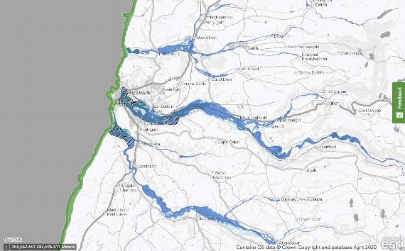
A new flood risk map, released to help inform future planning developments, demonstrates large swathes of mid Wales to be at risk of flooding both from the sea and rivers.
Natural Resources Wales launched the Flood Map for Planning today, with the aim of giving users the most up to date and accurate flood risk information in order to plan the siting of developments effectively.
The projected year for the map’s predictions is 2120.


Further in land, other areas along the Afon Dyfi, such as parts of Machynlleth, will have a one in 100 chance or greater of river flooding in any given year.
In Aberystwyth, only parts of the town will have a one in 200 chance of sea flooding. However, Aberystwyth and other communities along the Afon Rheidol and Afon Ystwyth will have a one in 100 chance or greater of river flooding.
Further south in the county, areas around the Afon Teifi, including a large area of Lampeter, will also have a one in 100 chance or greater of river flooding.
This map comes after Climate Central released a map, in August of this year, predicting much of mid Wales to be below annual flood level by 2030.
Insurance costs related to flooding totalled around £81 million in Wales last year, largely impacted by the effects of Storms Ciara, Dennis and Jorge in February which flooded over 3,000 properties. This map will allow developers to avoid and/or plan around flood risk when building new homes or businesses.
The new map is based on the latest and most accurate flood risk modelling technology for the main sources of flood risk.
Mark Pugh, principle advisor for flood risk analysis for NRW, said: “Flooding can devastate communities and the impacts of climate change mean that we’re likely to see more extreme weather events in the future. Being aware and keeping informed about flood risk is more important than ever, especially when it comes to building projects.
“Our new map is a big improvement on our old one, using the latest, most up to date data to give a clear assessment of an area’s flood risk so that people and organisations are as informed as possible while planning their projects.
“Ignoring an area’s flood risk can lead to developments at inappropriate sites with the potential for massive future costs to reduce flood risk. We encourage any company or organisation to include this improved service as part of their planning process.”
The new map is available to view on the NRW website at https://naturalresourceswales.gov.uk/flooding
Comments
This article has no comments yet. Be the first to leave a comment.