

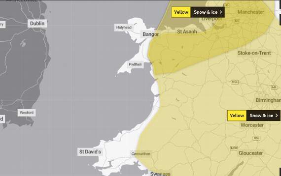
MUCH of Wales could wake up to a dusting of snow tomorrow morning according to meteorologists – but not those in coastal areas.
A yellow weather warning for snow and ice has been issued for much of Wales between midnight tonight and 6pm on Monday, with the Met Office saying that a band of rain may turn to snow, which along with widespread ice, could lead to the potential for some disruption to travel and utilities.
The weather warning does not currently cover any coastal areas of Ceredigion or Gwynedd but predicting where snow will fall is proving ‘tricky’ according to BBC weatherman Derek Brockway, who tweeted that weather models were not pinning down details of snowfall even at this late stage.
The Met Office warns: “An area of rain is likely to move south through Sunday night and Monday across parts of England and Wales.



.jpeg?width=209&height=140&crop=209:145,smart&quality=75)
“There is the potential for this to turn to snow for a time.
“There is a lot of uncertainty in where snow develops with some areas seeing little or no accumulations.
“However, there is a very low likelihood of 1-3 cm, and locally 5-10 cm falling in a few places, particularly over higher ground of Wales above 200 metres.
“As well as snow, widespread ice may also be an issue, especially where treatment has been washed off road surfaces.”
The weather forecast for Monday also predicts some thunder along the west coast of Wales with wintry showers, heavy at times moving in from the west with cold conditions throughout the day.
Further showers, wintry at times, particularly along coasts are expected between Tuesday and Thursday, with the potential for freezing fog.
Comments
This article has no comments yet. Be the first to leave a comment.