
People are being warned to stay away from promenades in Ceredigion and Gwynedd as Storm Bram approaches.
Yellow and amber weather warnings have been issued by the Met Office and Natural Resources Wales is warning that strong winds, coupled with high tides, could bring large waves to the Cardigan Bay coast.
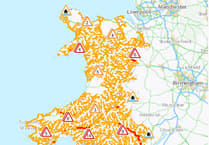
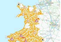
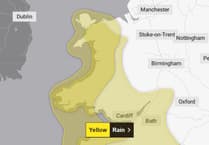
There are two yellow weather warnings in place for later on Monday evening in mid and west Wales, with south Wales having its weather warning upgraded to amber.
NRW is asking people to be vigilant and prepared as Storm Bram is expected to lead to flooding and disruption across Wales.

There is the potential for significant impacts with the worst being felt in South Wales, the environment watchdog says.
A Met Office Amber warning for rain is in place for parts of South Wales from midnight until 10am on Tuesday (December 9).
It covers Blaenau Gwent, Bridgend, Caerphilly, Carmarthenshire, Merthyr Tydfil, Monmouthshire, Neath Port Talbot, Powys, Rhondda Cynon Taf, Swansea and Torfaen.
A Yellow warning for rain for Wales is in force from 6pm today until 2pm tomorrow with a Yellow warning for wind covering large parts of Wales from 10pm today until 4pm tomorrow.
High tides combined with strong winds could also see very large waves in Gwynedd and Ceredigion in particular, and we are advising people to stay clear of promenades and the sea.
Surface water issues are expected, and we are calling on people to keep away from swollen riverbanks and not to drive or walk through floodwater.
People are being urged to consider any steps they may need to take now to be prepared.
Register for NRW’s free flood warning service at www.naturalresources.wales/flooding or by calling Floodline on 0345 988 1188.
Charlotte Morgan, Natural Resources Wales' Duty Tactical Manager, said: “We are asking people to be alert for potential flooding with heavy rain predicted through today (Monday) and overnight, especially in parts of South Wales.
“We’re urging people to be vigilant and to prepare for potential flooding now. You can check if you live in an area at risk of flooding on our website and sign up for our free flood warning service.
“We also want to remind people to keep away from swollen riverbanks and not to drive or walk through floodwaters as you don’t know what lies beneath.
“We are expecting to see very large waves and are advising people to stay clear of promenades and seafronts as you could be swept away by large waves or hit by debris.
“Our thoughts are with those communities who have recently been impacted, and they could potentially be impacted again during this event.
“If flooding is forecast in your area, we want to make sure people are doing all they can to keep themselves safe. Think about preparing a flood kit with any important documents and medication, moving your car to higher ground and moving treasured possessions upstairs or to a higher place.
“We do not provide flood warnings for flooding from surface water, so it’s important for everyone to know their flood risk.
“Keep an eye on weather forecasts and visit our website for the latest information on the flood warnings, and find practical advice on what to do before, during and after a flood.”

A flood alert has also been issued for the coast between Cardigan and Clarach.
Natural Resources Wales says: “The risk of flooding as a result of the combination of the high tides and weather conditions is expected to continue for the morning tide on Monday the 8 December through until the evening tide on Tuesday the 9 December.
“Flooding of low-lying land and roads is expected around the periods of each high tide. Impacts are currently expected to be greatest for the tides on Tuesday, as a new storm system is expected to bring large waves.
“Be careful on beaches, coastal footpaths, roads, and low lying land close to estuaries. Wave overtopping is possible at the most exposed coastal sites. We will continue to monitor the situation. We will update this message if the situation changes.”
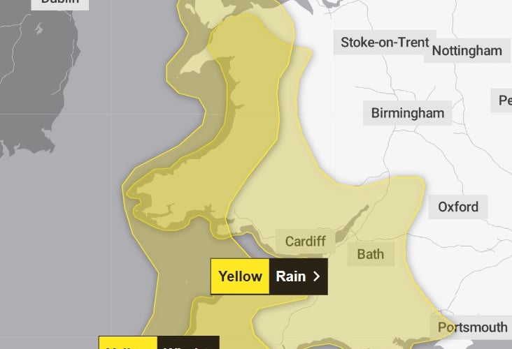
The Met Office rain warning begins at 6pm on Monday and runs until 2pm Tuesday, with the Met Office saying up to 80mm of rainfall is possible in high ground across Wales.
The warning says: "Outbreaks of rain will become persistent and heavy on Monday night into Tuesday morning.
"There will naturally be some variation in rainfall totals across the area, but accumulations of 20-40 mm are likely in quite a few places, with 60-80 mm over Dartmoor and high ground in Wales. "There is a chance of up to 100 mm falling over the most exposed, prone hills.
"Given the saturated nature of the ground, this is likely to lead to some flooding in places and transport disruption. Rain will also be accompanied by strengthening southerly winds, which may exacerbate impacts."
A second warning for strong winds comes into force from 10pm on Monday and runs until 4pm on Tuesday.
This warning states: "South to southwesterly winds will strengthen on Monday night and remain strong and gusty into Tuesday morning, before gradually easing through Tuesday afternoon.
"Peak gusts of 40-50 mph are expected fairly widely, but gusts of 60-70 mph will be possible along some exposed coasts and over/to the north of high ground.
"There is a small chance of gusts in excess of 70 mph over northwest Wales."
Flood Alerts and Flood Warnings are updated on the Natural Resources Wales website every 15 minutes and are available to view at www.naturalresources.wales/flooding
Information and updates are also available by calling Floodline on 0345 988 1188.
Comments
This article has no comments yet. Be the first to leave a comment.