Forecasters have warned that a marine heatwave in the waters around the UK could hit 'extreme levels' next week.
Surface waters in Northwest European seas are currently experiencing moderate to severe marine heatwave conditions, with widespread areas of “strong” conditions and some locations reaching “severe”.
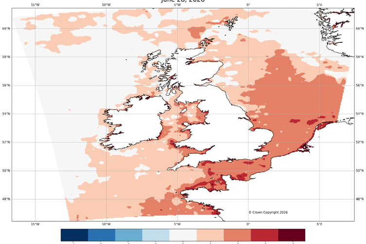
This means that waters have reached temperatures usually expected in August and are on average 2°C warmer than usual, locally reaching +4-5°C anomalies offshore parts of the Welsh and English coasts.
These elevated sea-surface temperatures have developed rapidly partially because of last week’s record-breaking atmospheric heatwave and could intensify further in the coming week when settled and sunny weather is likely to return.
The provisional UK June temperature record was exceeded on three consecutive days last week. Typically lagging inland weather by around 3-5 days, sea-surface temperatures have responded quickly, with the Bay of Biscay reaching unprecedented values for June.
While this exceptional land heatwave was primarily driven by atmospheric conditions, the surrounding marine environment played a role in prolonging warmth on land as the heatwave declined, when light winds favoured the movement of warmer-than-average marine air inland.
Across UK waters, widespread Category 2 marine heatwave conditions are present around much of the English and Welsh coastlines.
In tidally-mixed regions such as the Irish Sea, English Channel and southern North Sea, temperatures are elevated not only at the surface but also at depth, with anomalies of around +2°C observed below the surface. Elsewhere, warming is largely confined to the upper ocean layers.
Looking ahead, inland temperatures are forecast to rise again next week.
While the likelihood of reaching the extreme temperatures and humidity levels observed last week is currently low, a renewed period of warm weather is in the forecast.
.png?width=209&height=140&crop=209:145,smart&quality=75)


If this occurs, the sea surface will have limited opportunity to cool. This raises the possibility that the current marine heatwave could intensify further, potentially reaching Category 4, classified as “extreme” - a level rarely recorded in UK waters.
This week, the Copernicus Climate Change Service (C3S) and the Copernicus Marine Service (CMEMS) confirmed that global sea surface temperatures (SSTs) have surpassed the previous records for this time of year set in 2023 and 2024. This new seasonal high had been anticipated following the development of El Niño conditions in the Equatorial Pacific, which were formally announced by the World Meteorological Organization (WMO) on 2 June 2026, alongside persistently elevated SSTs observed across several ocean regions in recent months. These record temperatures are expected to have wide-ranging impacts on weather patterns, the global climate, and marine ecosystems
Copernicus have also reported above-average sea-surface temperatures across European seas at the end of June 2026.
Dr Ségolène Berthou, Air-Sea Interaction Specialist at the Met Office, said: “Marine heatwaves around the UK have developed rapidly following the recent heat dome, and we are now seeing widespread strong to locally severe conditions.
“This is the third and most intense marine heatwave we have seen this year.
“While these warmer seas did not significantly increase peak temperatures on land, they reduced night-time cooling and helped sustain warmth, particularly in coastal areas.
“With further sunny and calm weather likely next week, there will be little opportunity for the ocean to release this excess heat. This means the surface marine heatwave could intensify further, potentially reaching extreme levels in the south. Such conditions would be highly unusual for UK waters.”
Prof. John K. Pinnegar is the Principal Scientist and Lead Advisor (Climate Change) at CEFAS. He said: “Marine heatwaves can have significant impacts on ecosystems and wildlife. Prolonged periods of unusually warm sea temperatures can lead to shifts in fish populations, damage important habitats such as seagrass and kelp, and increase the likelihood of harmful algal blooms. These changes can result in mass-mortality events for some marine species and alter the distribution of commercially-important fish and shellfish.
“Prolonged periods of elevated seawater temperatures can also encourage new species to visit UK waters, establish new populations, potentially shaking up UK ecosystems. A recent example includes the population bloom of common octopus we've been experiencing since last year, with serious negative consequences for crab and lobster fisheries in southwest England.”
Holly Clements, Met Office Head of Warnings and Guidance, said: “It is vital for the public to understand that although sea-surface temperatures are currently well above average in many coastal locations, this does not avoid the risk of cold-water shock.
“With warmer weather approaching, and even with marine heatwave conditions, it’s important to remember that the water around the UK is still cold. Entering it unexpectedly can lead to cold-water shock.”
The Met Office says it continues to monitor and forecast both atmospheric and oceanic conditions closely, as interactions between the two can influence the duration and impacts of heat events across the UK.
Comments
This article has no comments yet. Be the first to leave a comment.