
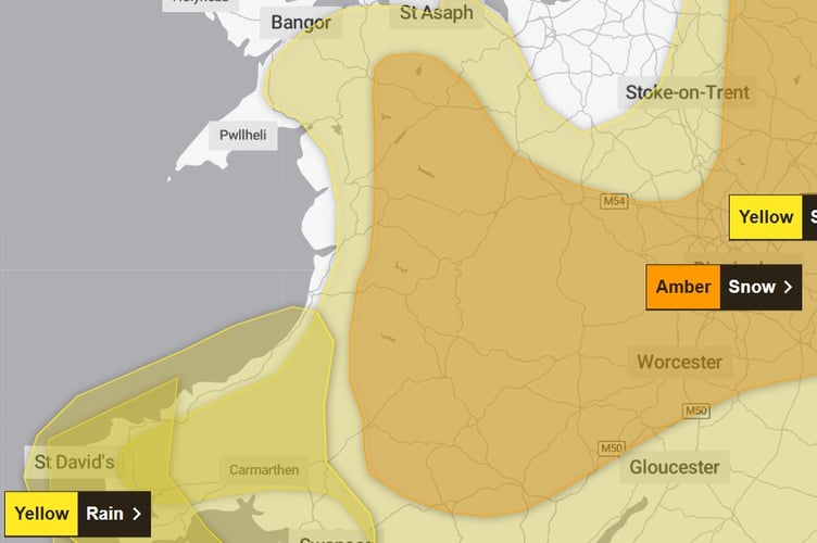
The Met Office has upgraded its warning for heavy snow to amber as Storm Goretti approaches Wales.
The warning comes into force at 8pm on Thursday and runs until 9am on Friday.
Forecasters say heavy snow, associated with Storm Goretti, is likely to lead to disruption and dangerous travelling conditions Thursday night into Friday.
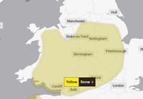
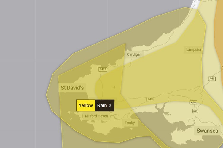
There is also a yellow weather warning for snow in place, but both avoid coastal regions of Cardigan Bay.

The amber warning, which covers most of inland Wales, reads: "Rain associated with Storm Goretti will turn readily to heavy snow on Thursday evening, initially on hills and then to lower levels overnight, before easing through the course of Friday morning. "Accumulations of 10-15 cm are likely fairly widely, with the potential for 20-30 cm in some locations, mainly on hills above 200 metre elevation, more especially in Wales and/or the Peak District.
"Snow will ease through the course of Friday morning, turning more to rain or sleet at times at low levels, but disruption is likely to persist into Friday after snow stops falling.
"There is some uncertainty over the exact track of Storm Goretti, which will influence the locations most likely to see disruptive snow, and it is possible this warning may be updated."
The yellow warning runs from 5pm on Thursday until midday on Friday.
Forecasters add that the low pressure system has been named by Meteo France, as the strongest winds associated with Storm Goretti are most likely over northern France.
The Met Office adds that some rural communities could be cut off and power cuts are likely.
Along the coast, a yellow warning for heavy rain has been issued just south of Aberystwyth.
The warning runs from midday on Thursday until 10am on Friday and reads: “Outbreaks of rain will become persistent and heavy through Thursday afternoon, evening and night, before easing and clearing to the east by Friday morning.
“Heavy showers will follow for a time on Friday morning. Whilst this may fall as snow over hills, covered by a separate snow warning, rain accumulations of 20-40 mm are possible, with perhaps as much as 60 mm in a few places. This, combined with snow melt, may lead to some surface water flooding.”
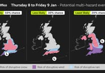
Met Office Chief Forecaster Neil Armstrong said: “Storm Goretti will be a multi-hazard event, with the most significant impacts from snow in parts of Wales and the Midlands, though rain and strong winds also have the potential to bring disruption to many.
“Goretti will bring snow on its northern edge, this most likely over Wales and the Midlands. Here accumulations of 5-10 cm are likely widely, with 15-25 cm in some places, especially hills, and perhaps up to 30 cm very locally. An Amber warning has been issued where the greatest risk of disruption is likely on Thursday night into Friday morning, though updates may be required as confidence increases in the exact track of Storm Goretti.”
RAC breakdown spokesperson Alice Simpson said: “In the areas worst affected by Storm Goretti, drivers need to be considering if it’s safe to get behind the wheel. As temperatures plummet, breakdowns rise, especially as older, less reliable batteries tend to fail more often in cold conditions.
“The key is allowing more time at every stage of the journey, whether that's clearing vehicles of snow and ice before setting off or reducing the speed at which you’re travelling to suit the conditions.
“Never be tempted to use hot water to clear a frozen windscreen which, rather than being a ‘hack’ could actually lead to an expensive crack. Instead, leave more time before setting off and carry a decent scraper and de-icer so you can clear the windscreen quickly. Stick to major roads that are more likely to be clear of snow and stay tuned to weather forecasts to decide if it’s a good idea to drive.
“It’s important to have plenty of screen wash that protects down to at least -10°C, ensuring you always have a clear view due to all the dirt from gritted roads.”
Storm Goretti’s influence will wane on Friday evening as the system moves to the east of England. There will be a short-lived interlude of calmer weather for many on Saturday with rain showers easing, cloud for those in the east, and sunny spells possible elsewhere.
However, by Sunday the forecast becomes very uncertain, as Met Office Deputy Chief Forecaster Mark Sidaway explains.
He said: “It’ll remain cold or very cold to start the weekend, although for most it will be dry. We then have very large uncertainties in the forecast by Sunday and Monday as milder air from the Atlantic tries to displace the cold air over the UK. This set up brings a risk of some further widespread snowfall, so it’s important to stay aware of the forecast and any warnings which may be issued over the next few days.”
Comments
This article has no comments yet. Be the first to leave a comment.