
A map using new data to predict sea level rises paints a concerning picture for north Ceredigion communities.
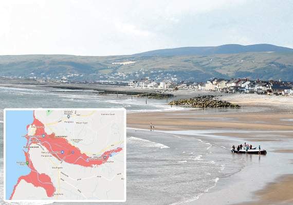
The sea level risk map, released by an independent climate change organisation of leading scientists, predicts that a large part of Aberystwyth and much of Borth and Ynyslas will be underwater in as little as nine years time.
Climate Central has published an interactive map, which they say is based on peer-reviewed science in leading journals, predicts a large portion of Aberystwyth and Clarach, as well as all of Borth and Ynyslas, will be at risk of sea level rise by 2030.
This map comes after the United Nation’s climate science body, Intergovernmental Panel on Climate Change, released their major report on the physical changes happening and project to happen due to climate change as well as human involvement in these changes.


The report states we are set to pass 1.5 degrees warming by 2040, unless drastic reductions in CO2 are seen. It also highlights human activity as driving extreme weather, that we know more about regional climate impacts, methane emissions are an important lever, and that we are closer to irreversible tipping points.
Welsh Conservative Shadow Minister for Climate Change, Janet Finch Saunders MS commented on the “worrying” Climate Central map: “This map reinforces that we cannot sit idly by; we either act now or face horrendous flooding which could affect large swathes of land in Wales.
“Welsh Conservatives have been clear from the outset that we need to invest more money into flood defences to ensure they are fit for purpose, as well as setting up a National Flood Agency to co-ordinate risk management and respond to flooding events.
“Labour ministers in Cardiff Bay must take decisive action to tackle climate change, or they run the risk of people across the country facing complete ruin in years to come.
“The Welsh Labour Government need to stop pontificating over minor issues which don’t affect the average Welsh person and get on with taking serious action that matches the situation we’re in.”
On 30 July, the Welsh Government released a “route map for decarbonisation across the Welsh public sector”, which sets out a “strategic overview of the key priority areas for action and milestones needed for the Welsh public sector to reach net zero greenhouse gas emissions by 2030”.
They highlighted buildings, mobility and transport, procurement, and land use as the “priority areas for action”.
The interactive Climate Central map can be seen here.
The IPCC report can be viewed at https://www.ipcc.ch/report/ar6/wg1/
Comments
This article has no comments yet. Be the first to leave a comment.