
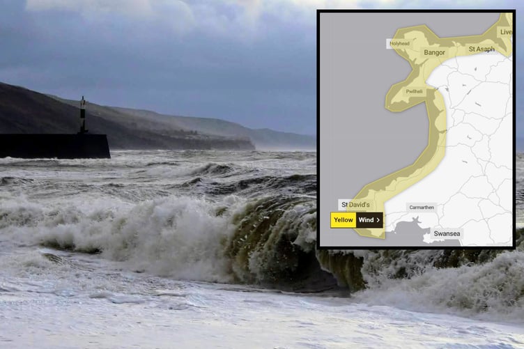
THE wind and rain looks set to continue this week with a fresh warning being issued for Tuesday across western coasts of Wales.
Hot on the heels of Storm Kathleen, Storm Pierrick - named by meteorologists in France - is set to bring gusts of 65mph and heavy showers on Tuesday across coastal regions.
The yellow warning is in place from 1am Tuesday until 3pm, stating that strong winds may bring hazardous coastal conditions and could cause some travel disruption.
The Met Office says: "A spell of strong winds blowing from the northwest will affect this region on Tuesday.
.png?width=209&height=140&crop=209:145,smart&quality=75)

-the-UKs-leading-biennial-exhibition.png?width=209&height=140&crop=209:145,smart&quality=75)

"Initially arriving across Southwest Wales, in the early hours of Tuesday, and reaching North Wales and Northwest England during Tuesday morning.
"Gusts will reach 40-50 mph widely, with 60 or 65 mph gusts expected for exposed coasts of Southwest and West Wales overnight.
"Winds will likely ease (although still remaining breezy) across Southwest and West Wales before dawn on Tuesday."
The Met Office is advising people to be aware of large waves and to take care if walking near cliffs.
The forecast for Aberystwyth
Tonight:
A windy end to the day with coastal gales possible along exposed coasts. Outbreaks of rain continuing throughout the night, becoming heavier and more persistent by dawn. Minimum temperature 4 °C.
Tuesday:
An unsettled start with strong winds and heavy rain, turning more showery through the afternoon with some brighter intervals developing. Feeling cooler with winds easing during the evening. Maximum temperature 12 °C.
Outlook for Wednesday to Friday:
Chillier and drier to start on Wednesday ahead of further rain arriving from the west. Rather cloudy on Thursday and Friday with rain or drizzle at times. Feeling warmer.
Comments
This article has no comments yet. Be the first to leave a comment.