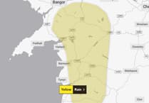
The Met Office has issued a yellow weather warning for Thursday, with strong winds, thunder and heavy rain likely.
The warning runs from midnight on Thursday, 12 June until 1pm.
The Met Office says: "An area of rain will move northwards across parts of southwest England and Wales during Thursday morning, before clearing later.
"The rain will be locally heavy with thunderstorms. A few places perhaps receiving 10-20 mm of rain in an hour, and 30-40 mm in 3 hours or less, leading to a risk of disruption.
"Winds will also be strong at times, perhaps gusting to 40-50 mph around hills and coasts.
The warning adds that there there is a good chance driving conditions will be affected by spray, standing water and/or hail, leading to longer journey times by car and bus.
Met Office Chief Meteorologist Neil Armstrong said: “A weather system will push northwards through tomorrow, bringing heavy rain and a risk of thunderstorms to parts of southwest England, most of Wales, and later into Northern Ireland.
“40mm of rain could fall in 3 hours or less leading to the potential for disruption. Further thunderstorms will develop during the afternoon across England and Wales, moving quickly northwards with hail and lightning. Temperatures will remain high, with 26 or 27°C possible again in the north Midlands and parts of north London.
“Further rain is expected across western areas early on Friday as a low-pressure system to the west draws in more warm, moist air from the south. A yellow thunderstorm warning has been issued from 3pm Friday to Saturday morning covering parts of the South East and East Anglia.”
Deputy Chief Meteorologist Tony Wisson said: “By Friday afternoon and evening, heavy and thundery showers are likely to spread across southeastern England and East Anglia, tracking north-eastwards overnight.
“There is currently some uncertainty around the exact location and intensity of the thunderstorms, but there is a risk that some areas could see 30 to 50mm of rain, with a risk of even larger accumulations possible.
“With much of the rain falling in a short space of time there is a risk of impacts such as surface water flooding. Frequent lightning, gusty winds and hail could pose additional hazards. Updates to this warning are expected as confidence increases on the exact location of the greatest risk of the heaviest downpours.”
By the end of the weekend, the humid and thundery airmass will be displaced by fresher and generally more settled conditions spreading east across the UK.
The south is forecast to become more settled with temperatures a little above average while northern parts of the UK, especially the northwest, are likely to be more changeable, with spells of stronger winds, cloud and some rain at times.


Comments
This article has no comments yet. Be the first to leave a comment.