

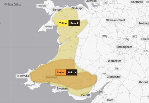
A WEEKEND weather warning for heavy rain has been extended and upgraded to an amber warning in some regions.
The amber weather warning for rain covers an area of south and west Wales as far north as Lampeter, but a yellow warning for rain has also been added for other parts of West and North Wales.
The Met Office says that as much as 200mm could fall in less than 24 hours.
The amber weather warning is in place from today (Friday until Saturday, 20 February.




Heavy, persistent rainfall is expected to result in some flooding and disruption to transport and utilities.
Flood alerts for Ceredigion Rivers have already been issued by Natural Resources Wales.
A spokesperson for Ceredigion County Council said: “It is likely that some of these, particularly in the Mid and South of the county will be increased to Flood Warnings with a potential for some Severe Flood Warnings.
“This could impact property near the rivers, as well as bridges crossing the rivers, resulting in potential road closures.”
The amber warning, which is active from 8pm this evening until 6pm on Saturday, states: "A slow moving frontal system is expected to bring persistent and at times heavy rainfall to parts of Wales through Friday and much of Saturday.
"Around 35 to 70mm of rainfall is expected widely within the warning area, with high ground and upslopes exposed to the south and southwest expected to see significantly more.
"Here rainfall totals are expected to reach 100 to 150 mm quite widely, with as much as 200mm possible on the highest ground of south Wales before the rain band clears to the east during the late afternoon and evening.
"As well as heavy rain, strong to gale force southerly winds will be an additional hazard through Saturday."
The yellow warning which covers large parts of North and West Wales states: “Following recent rainfall over the last few days, the rain that is already falling will become slow moving over Wales through the rest of today.
"Whilst many places will see a spell of heavy rain, the high ground in south Wales, exposed to the strong southerly winds, will likely see the largest rainfall totals. Here, some 80-120 mm of rain is possible, with the most exposed parts of the Brecon Beacons seeing a possible 150-170 mm and some areas potentially seeing up to 200 mm by the end of Saturday.
"The rain now looks most likely to finally clear very late on Saturday, although precise timings continue to be somewhat uncertain.
"The cumulative effects of the rainfall on increasingly saturated ground mean that impacts are most likely to develop during Saturday.
"As well as heavy rain, strong to gale force southerly winds will be an additional hazard through Saturday."
There are currently over 20 active flood warnings on the Natural Resources Wales website.
Comments
This article has no comments yet. Be the first to leave a comment.