
Ceredigion is to foot the bill for dredging Aberaeron’s harbour entrance.
Three months after the £36m flood defence project was completed, Ceredigion County Council has acknowledged it will be paying for remedial works.
The long-awaited flood defences for the town included a controversial breakwater extending out of the harbour mouth facing southwards.
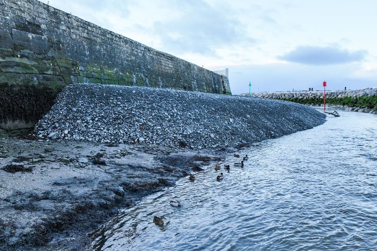


The large breakwater has become a scoop for the debris of the sea floor, catching the shingle, silt and sand pushed up by the typical south-to-north longshore drift.
This has created a growing shingle bank in the harbour entrance, making it “impassable” to all but dinghies according to harbour users.
The council has since posted a ‘Local Notice to Mariners’ online warning of the potential hazard, and is consulting on the best way to remove the bank sometime this Spring.
A spokesperson said: “The council is currently investigating options for removal/reduction of the shingle bank in the next two to three months.
“Removal of the shingle bank will be funded by Ceredigion County Council.”
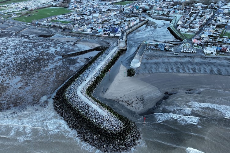
It comes as new footage reveals the enormity of the growing shingle bank.
Harbour user Bryn Raw-Rees went out with his drone to capture the mound at low tide.
The local surfer, who has used the harbour for 30 years and is a former geographic analyst, said: “Really, I was just curious about the mechanics of the new ‘mound’ and wanted to analyse it from above.
“I think the footage [from 5 January] shows exactly what’s happening.”

The footage shows a large buildup of shingle on the south side of the harbour entrance, and a lower buildup of sand that both appear to be coming from the beach to the south of the harbour.
The project, which was years in the making, was designed to protect the harbour from floods, which locals defend as doing just that.
However, mariners have come out against the design, which they consistently state is “facing the wrong direction”.
Bryn brands it as “GCSE level geography”: “My take is that they’ve interrupted the predominant south to north longshore drift.
“This has created two new accretion zones as the natural transport of sediment has been prevented.
“The mound will keep getting bigger, as will the sandbank, until the south-to-north transport [of sediment] can happen again.
“The shoreline north of the breakwater will also be sediment-starved.
“Basically, the breakwater is too large and is designed to work against nature instead of with it.
“It should have been built smaller and the other way round to block the predominant and much more powerful South Westerly swells, to allow longshore transport of sediment and eventually that would have built up Cadwgan Reef, which would have helped block North Westerly swells.”

Ceredigion County Council has defended the scheme which built the breakwater facing south, as data showed the storms that caused the most flooding in Aberaeron came with winds that were from the West/ North West.
A spokesperson for the council added that sediment build-up was predicted at the design stage, but that any intervention needed to be done after the new features had been allowed time to settle.
The mound, dubbed by locals as ‘Eifion’s Mound’ after the council’s CEO, has already been removed once before completion of the project in October 2025.
The spokesperson said: “The council are in the process of consulting its engineering consultants on this matter to formulate an agreed plan moving forward.
“This will consider various alternatives on how to deal with the issue.”
Comments
This article has no comments yet. Be the first to leave a comment.